Tuesday, August 18, 2015

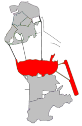
Taipa, Macau


From Wikipedia, the free encyclopedia
For the town in New Zealand, see Taipa-Mangonui. For the Nakh word тайпа, meaning “clan”, see Teip.
Nossa Senhora do Carmo (Taipa)
嘉模堂區(氹仔)
Our Lady of Carmel
Freguesia
Macau International Airport
Freguesia de Nossa Senhora do Carmo in Macau
Country Macau
Region Municipality of das Ilhas
Area
 • Total 7.6 km2 (2.9 sq mi)
Population (2013)
 • Total 92,200
 • Density 12,000/km2 (31,000/sq mi)
Time zone Macau Standard (UTC+8)
Taipa Island
Chinese name
Chinese 氹仔島

Cantonese Jyutping Tam5 Zai2 Dou2
Portuguese name
Portuguese Ilha da Taipa
Freguesia de Nossa Senhora do Carmo
Chinese name
Traditional Chinese 嘉模堂區
Simplified Chinese 嘉模堂区

Cantonese Jyutping Gaa1 Mou4 Tong4 Koe1
Portuguese name
Portuguese Freguesia de Nossa Senhora do Carmo
Ponte de Amizade (Friendship Bridge) from the Macau Peninsula (left) to the Taipa Island (right), Macau
Taipa is an island in the Chinese special administrative region of Macau. It is represented by Freguesia de Nossa Senhora do Carmo, which is named for Our Lady of Carmel Church on the island.

Contents

Geography

Taipa is 2.5 kilometres (1.6 mi) from Macau Peninsula and east of the Lesser Hengqin Island of Zhuhai, Guangdong Province. Macau International Airport, University of Macau, Macau Jockey Club and Macau Stadium are situated in Taipa.
Most Chinese settlement of Taipa occurred during the Southern Song Dynasty, while the Portuguese occupied the island in 1851. Prior to land reclamation, Taipa consisted of two islands: Greater Taipa and Lesser Taipa.
The 159.1 metres (522 ft) Big Taipa Hill (大氹山) is to the east, and Small Taipa Hill (小氹山) to the west. Central Taipa is a plain as a result of siltation and land reclamation. Initially Taipa was connected to Coloane Island only by the Estrada do Istmo (路氹連貫公路); but the area called Cotai, built on reclaimed land from 2004 and which is home to mega-resorts, casinos, and convention and exhibition centers, has now connected the two islands into one piece of land. Taipa is connected to peninsular Macau by Governador Nobre de Carvalho Bridge, Friendship Bridge and the Sai Van Bridge.
Taipa is predominantly a growing residential area with many new apartment complexes, mostly up-scale, under construction as of 2006. As a new town of Macau, Taipa has better city planning than Macau Peninsula; however, many people choose to live in Macau Peninsula since most of the famous schools are located there (apart from the newer International School of Macao, which is the premier international school in Macau).

The names of Taipa

In Cantonese, Taipa has been known by many names over time, including 龍環 (Lung Waan, meaning "Dragon Ring"), 雞頸 (Gai Geng, "Chicken's neck"), 潭仔 (Tam Tsai, "Pool"), and 龍頭環 (Lung Tau Waan, "Dragon's-Head Ring").
The Portuguese and English name "Taipa" comes from the Chinese pronunciation of 氹仔 in Min Nan /tiap-á/ (similar to "tiamp-a") then became "Taipa"[citation needed]. The putonghua pinyin for 氹仔 is dàngzǎi, and this is how the island is referred to in Mandarin. Both the character 氹 and the alternative form 凼 mean cesspit, but are obsolete in modern Chinese, and only used in relation to Taipa and the Macau-Taipa Bridge (澳氹大桥 àodàng dàqiáo). The character , or , is often missing from mobile phone and computer input systems.
Another version according to legend, comes from an exchange between early Portuguese settlers on Taipa and local Chinese settlers. The Portuguese asked the Chinese the name (nome in Portuguese) of the place. The Chinese settlers were local grocery shopkeepers and spoke no Portuguese, but took the Portuguese nome for the Chinese 糯米, "sticky rice", which is pronounced similar to nome in Cantonese. Thinking the Portuguese settlers were asking if they sold sticky rice, the Chinese responded with "大把," pronounced "daai ba" in Cantonese, meaning "a lot." The Portuguese, hearing the response, took this to be the name of the place. There is, however, no historical evidence to support this story. "Taipa" is also what the Portuguese call the clay-mud, rammed into moulds, used to build mud houses in Portugal in times gone by, in recent times referred to as Rammed Earth.
It is also worth noting that, as the great majority of the population in Taipa and Macau is Chinese, however there is a growing community of expatriates living in Taipa who work at the Casinos on the Cotai Strip. Most people refer to this island by its Cantonese name, "Tamzai", and most taxi drivers and bus drivers will not understand if asked how to go to "Taipa."

Tourism

Night view of the Old bridge
Ponte de Amizade and the HK-Macau Ferry Terminal
Religious
  • Pou Tai Un Temple (菩提園 or 菩提襌院): named after bodhi tree
  • Small Kun Yam Temple (觀音岩)
  • Tin Hau Temple (天后宮)
  • Sam Po Temple (三婆廟): dedicated to the elder sister of Tin Hau
  • Pak Tai Temple (北帝廟): dedicated to the Taoist God of the North
  • Four-faced Buddha (四面佛): purchased from Thailand in 1985
  • Church of Our Lady of Carmel (嘉模聖母教堂): Catholic, Taipa belongs to the Freguesia de Nossa Senhora do Carmo (聖嘉模堂區).
Other

See also

External links

Friday, August 7, 2015

Cityscape of Providence, Rhode Island


Perspective of Westminster Street
Downtown Providence at Burnside Park
The Downtown Providence skyline, viewed from College Hill on the city's East Side
The city of Providence is geographically very compact, characteristic of eastern seaboard cities that developed prior to use of the automobile. It is among the most densely populated cities in the country. For this reason, Providence has the eighth-highest percentage of pedestrian commuters.[24][25] The street layout is irregular—over one thousand streets (a great number for the city's size) run haphazardly, connecting and radiating from traditionally bustling places like Market Square.[26]
Downtown Providence has numerous 19th-century mercantile buildings in the Federal and Victorian architectural styles, as well as several post-modern and modernist buildings, located throughout the area. In particular, a fairly clear spatial separation appears between the areas of pre-1980s development and post-1980s development. West Exchange Street and Exchange Terrace serve as rough boundaries between the two.
The newer area, sometimes called "Capitol Center",[27] includes Providence Place Mall (1999), a Westin hotel (1993) and The Residences at the Westin (2007), GTECH Corporation (2006), Waterplace condominiums (2007), and Waterplace Park (1994); the area tends toward newer development, since much of it is land reclaimed in the 1970s from a mass of railroad tracks referred to colloquially as the "Chinese Wall".[28] This part of Downtown is characterized by open spaces, wide roads, and intent landscaping.
The historic part of downtown has many streetscapes that look as they did eighty years ago. Many of the state's tallest buildings are found here. The largest structure, to date, is the art-deco-styled former Industrial Trust Tower, currently the Bank of America Building at 426 feet (130 m).[29] By contrast, nearby to it is the second tallest One Financial Plaza, designed in modern taut-skin cladding, constructed a half-century later.[30] In between the two is 50 Kennedy Plaza. The Textron Tower is also a core building to the modest Providence skyline. Downtown is also the home of the Providence Biltmore and Westminster Arcade, the oldest enclosed shopping mall in the U.S., built in 1828.[31]
The city's southern waterfront, away from the downtown core, is the location of many oil tanks, a docking station for a ferry boat, a non-profit sailing center, bars, strip clubs, and power plants. The Russian Submarine Museum was located here until 2008, after the submarine sank in a storm and was declared a loss. The Fox Point Hurricane Barrier is also found here, built to protect Providence from storm surge, like that which it had endured in the 1938 New England Hurricane and again in 1954 from Hurricane Carol.[32]
The majority of the cityscape comprises abandoned and revitalized industrial mills, double- and triple-decker housing (though row houses, found so commonly in other Northeast cities, are rare here),[33] a small number of high-rise buildings (predominantly for housing the elderly), and single family homes. I-95 serves as a physical barrier between the city's commercial core and neighborhoods such as Federal Hill, and the West End.

Climate

Waterplace Park
Providence has a humid continental or humid subtropical climate (Köppen Cfa or Dfa) depending on the January isotherm used, with warm summers, cold winters, and high humidity year-round. The USDA places the city in Hardiness zone 6b, with the suburbs falling in zones 6a - 7b.[34] The influence of the Atlantic Ocean keeps Providence, and the rest of the state of Rhode Island,[35] warmer than many inland locales in New England.[36][37] January is the coldest month with a daily mean of 29.2 °F (−1.6 °C), and low temperatures dropping to 10 °F (−12 °C) or lower an average of 11 days per winter,[38] while July is the warmest month with a daily mean of 73.5 °F (23.1 °C), and highs rising to 90 °F (32 °C) or higher an average of 10 days per summer.[38] Extremes range from −17 °F (−27 °C) on February 9, 1934 to 104 °F (40 °C) on August 2, 1975;[39] the record cold daily maximum is 1 °F (−17 °C) on February 5, 1918, while the record warm daily minimum is 80 °F (27 °C) on June 6, 1925.[38] Temperature readings of 0 °F (−18 °C) or lower are uncommon in Providence, and generally occur once every several years. The year which had the most days with a temperature reading of zero degrees or lower was 2015 with eight days so far; one day in January and seven days in February.[38] Conversely, temperature readings of 100 °F (38 °C) or higher are even rarer, and the year with the most days in this category was 1944 with three days, all of which were in August.[38]
As with the rest of the northeastern seaboard, Providence receives ample precipitation year-round. Monthly precipitation ranges from a high of 4.43 inches (112.5 mm) in March to a low of 3.17 inches (80.5 mm) in July.[39] In general, precipitation levels are slightly lesser in the summer months than the winter months, when powerful storms known as Nor'easters can cause significant snowfall and blizzard conditions. Although hurricanes are not frequent in coastal New England, Providence's location at the head of Narragansett Bay makes it vulnerable to them.

Queens, New York City

Neighborhoods

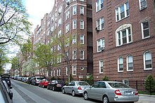
A typical residential street in Jackson Heights.
Long Island City is a neighborhood in western Queens.
Row houses are prominent in many Queens neighborhoods, including Ridgewood.
Four United States Postal Service post offices serve Queens, based roughly on those serving the towns in existence at the consolidation of the five boroughs into New York City: Long Island City (ZIP codes starting with 111), Jamaica (114), Flushing (113), and Far Rockaway (116). In addition the Floral Park post office (110), based in Nassau County, serves a small part of northeastern Queens. Each of these main post offices have neighborhood stations with individual ZIP codes, and unlike the other boroughs, these station names are often used in addressing letters. These ZIP codes do not always reflect traditional neighborhood names and boundaries; "East Elmhurst", for example, was largely coined by the USPS and is not an official community. Most neighborhoods have no solid boundaries. The Forest Hills and Rego Park neighborhoods, for instance, overlap.
Residents of Queens often closely identify with their neighborhood rather than with the borough or city. The borough is a patchwork of dozens of unique neighborhoods, each with its own distinct identity:

Demographics